
I created this map as part of of ESRI’s Cartography MOOC. I decided to query out the category 1 hurricanes by month to do a bit of analysis in regards to where hurricanes tend to occur throughout the calendar year.
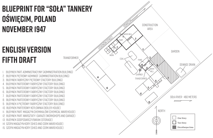
Map of Soła Tannery, Oświęcim, Poland, November 1947
This is another project I am working on with Jody Russell Manning, Ph.D., professor of history at Rowan University’s Center for Holocaust & Genocide Studies. I created this map using a hand-drawn “memory” map. The site is a tannery in Oświęcim (Auschwitz), Poland, used during WWII as a storage area for personal belongings of the prisoners. Later, in the 1990’s, the facility was used as a discotheque. A second map will be created using a similar map drawn from memory. As with the Dachau maps, this map was created in Adobe Illustrator CC.


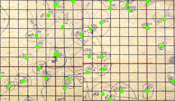
Digitization of Hand-Drawn Rowan University/Edelman Fossil Park Map
In close coordination with Zachary Christman, Associate Professor and GIS Program Director in Rowan University’s Department of Geography, Planning and Sustainability, I am in the process of digitizing the Rowan University/Edelman Fossil Park’s Fossil Map (https://www.rowan.edu/fossils/). The map is 1 square meter in size and contains roughly 1300 fossils. I first photographed small sections of the original map using a digital camera and then geo-rectified the photographs into one high-resolution digital map in ArcGIS. I then set about adding the approximate centroid location for each fossil. The next steps will include adding information like the location and depth of the fossil in hopes of better understanding where to dig next to find more fossils of the same specimen.


Remembrance and Development: Mapping structural changes in and around Dachau, 1945-2017
These maps were created in an interdisciplinary cooperation between myself and Jody Russell Manning, Ph.D., professor of history at Rowan University’s Center for Holocaust & Genocide Studies. I created these maps from numerous archival aerial photographs showing residential and commercial change around the former Dachau Concentration Camp, from 1945 to 2017. This research is ongoing and will result in a co-authored interdisciplinary journal article. These maps were created in Adobe Illustrator CC.


Geography Awareness Week 2017 Poster

2017 Solar Eclipse Waffle House Map (Useless Map #1)
Seeing as how most hotels, campsites and National Parks are going to be occupied with people wanting to see the solar eclipse, wouldn’t it be nice to see the eclipse while noshing on your favorite Waffle House dish?
Created in ArcGIS Online, this is the first in a series of maps that can only be described as useless.

Custom Color Palettes


I created these color palettes during my cartography class this summer. One is based on a birthday card that Barbara Botting made for me (http://www.studiobotting.com/). The other is based on a photo of my son’s yummy lunch. Please feel free to use.
Glassboro/Southern New Jersey Wetland Maps


These maps display the streams, watersheds and wetlands in and around Glassboro, New Jersey.
New Jersey Earthquake History Map (KML/KMZ)

This series of maps gives a brief introduction on the State of New Jersey’s earthquake history. I chose to examine the geologic history of New Jersey as it pertains to earthquakes. I am not originally from New Jersey so I did not know the frequency or magnitude of earthquakes that the state has experienced. I was surprised to find out that the state has had a lot of quakes over the years although for the most part they have not been too powerful.
I created layers in ArcGIS and converted them to KML/KMZ files and uploaded them to Google Earth Pro.


Plant Hardiness Zone Map with Custom Color Palette

Here is a plant hardiness zone map with data supplied by Bill Morris (http://wboykinm.github.io/opencv/). The custom color palette I created was inspired by the suite of colors used in Wes Anderson movies.
Farmers’ Markets in the Near-Northeast of Philadelphia

This map was created for my recent Cartography class. It shows some of the farmers’ markets in the River Wards sections of Philadelphia.
New Jersey Organic Farm Map

I created this map for a Cartography project. I envisioned the map as a poster in window of a corner store, showing some of the many organic farms throughout the state. New Jersey is not known for its organic farming but it definitely should be. The map was created in Adobe Illustrator. I traced the shape of the state and the North Arrow and the organic farm symbol were created custom as well.
